
This webpage is linked/generated by QR Code for Lycian Way, Step-by-Step Lycian Way. There is a QR code for each route where all the details, updates and latest news cannot be included in the book.
For each route additional and important informations will be shared from these links. Updates, latest news, explanations, photos, so that the book will be lighter in weight. No route descriptions here, only GPS (Wikiloc) link which is included in book as well.
What is included here?
1- Up-to-date information (if there is any - the latest status about the route will be shared here)
2- Wikiloc GPS link
3- Critical spots, not to be missed points and photos
4- Warnings (spots and photos)
5- More photos to describe the whole route
Please do not forget to include a photo and description (event, status, date etc.) for informational and evidential purposes. We may share your name here with a reference if you want to.
This is a collective contribution to develop a better trail for those who will walk after you.
IMPORTANT NOTE: All articles, photos and content on this book and blog subject to Law of Intellectual Property Rights. It cannot be copied without permission, the content, photos or some part of it cannot be used without showing the source, without getting the written permission of the author and website owner.
For each route additional and important informations will be shared from these links. Updates, latest news, explanations, photos, so that the book will be lighter in weight. No route descriptions here, only GPS (Wikiloc) link which is included in book as well.
What is included here?
1- Up-to-date information (if there is any - the latest status about the route will be shared here)
2- Wikiloc GPS link
3- Critical spots, not to be missed points and photos
4- Warnings (spots and photos)
5- More photos to describe the whole route
It may be useful and helpful for you to check these links before you set off
Do not hesitate to share your opinions, revision & update requests that you might have possibly detected during your walk. All views are welcome to the email address altugsenel@gmail.com
Please do not forget to include a photo and description (event, status, date etc.) for informational and evidential purposes. We may share your name here with a reference if you want to.
This is a collective contribution to develop a better trail for those who will walk after you.
IMPORTANT NOTE: All articles, photos and content on this book and blog subject to Law of Intellectual Property Rights. It cannot be copied without permission, the content, photos or some part of it cannot be used without showing the source, without getting the written permission of the author and website owner.
24A - Beycik - Tahtalı Dağı - Yayla Kuzdere / Wikiloc GPS kaydı - ERİŞİM için TIKLAYIN
 |
| Beycik'ten çıkış |
 |
| Su kaynağı ve yerel birkaç işletmenin de bulunduğu Emzikçeşme mevkisine doğru çam ormanından ve patikalardan yürünüyor |
 |
| Tahtalı'ya çıkış uzun ve yorucu |
 |
| 1000 metre yükseklikten sonra çam ağaçları yerini ardıç ve sedirlere bırakmaya başlıyor. |
 |
| Torosların endemiği, Sedir Ağaçları |
 |
| Tahtalı Dağı'nı aşmak yürüyüşçülerin doğada kendilerine olan güvenlerini arttırıyor |
 |
| Rotanın yürüyüş dönemi çok önemli.Beklentinizden farklı bir iklimle karşılaşabilirsiniz. Yola çıkmadan sosyal medya gruplarından veya bölge hava durumundan güncel durumu sorgulamanızı tavsiye ederim. Antalya veya Kemer kent merkezinin hava durumunu kontrol etmeniz yanıltıcı olabilir. |
 |
| Çukuryayla |
 |
| Çukuryayla |
 |
| Çukuryayla civarında çok sayıda irili ufaklı kamp için uygun düzlükler karşınıza çıkacak. |
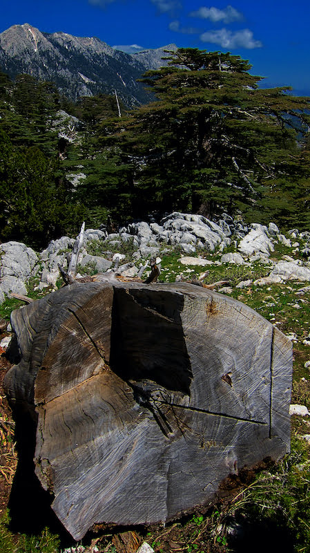 |
| Tüm coğrafya sedir ağaçları ile çevrilmiş durumda. Bu ağaçlar bugün koruma altında. |
 |
| Çukuryayla'dan Gürleyik mevkisine iniş |
 |
| Gürleyik mevkisi |
 |
| Gürleyik sonrası çam ormanına giriliyor. Bu rota sizi Yayla Kuzdere'ye ulaştıracak. |